Remote Sensing for OSINT
Overview
The analysis of satellite imagery is a foundational element of open source investigations. Its quality, quantity and availability has increased dramatically in the past decade. Capabilities and insights that were once only available to governments are now accessible to the general public. Satellite imagery is being used to collect evidence of genocide and other war crimes in Ukraine, Nigeria, Burundi, Cameroon, the DRC, South Sudan, Papua, and Venezuela. It has been used to monitor environmental degradation and hold extractive industries to account from Iraq to Guatemala. The ability to analyze satellite imagery is a critical skill for anyone interested in open source investigations.
Though no-code platforms such as Sentinelhub have been invaluable in allowing the OSINT community to access and process satellite imagery, the analytical capabilities of these platforms are limited. Google Earth Engine (GEE) is a cloud-based platform that stores petabytes of satellite imagery from a variety of sources and allows users to perform advanced analyses on Google servers for free using a browser-based interface. This textbook is designed for investigators who want to perform more sophisticated analysis using geospatial data, and assumes no prior knowledge of coding or remote sensing (satellite imagery analysis). It is organized into two parts: an introduction to remote sensing and GEE, and a series of case studies that demonstrate how to use GEE for open source investigations.
What is Google Earth Engine?
As geospatial datasets—particularly satellite imagery collections—increase in size, researchers are increasingly relying on cloud computing platforms such as Google Earth Engine (GEE) to analyze vast quantities of data.
GEE is free and allows users to write open-source code that can be run by others in one click, thereby yielding fully reproducible results. These features have put GEE on the cutting edge of scientific research. The following plot visualizes the number of journal articles conducted using different geospatial analysis software platforms:
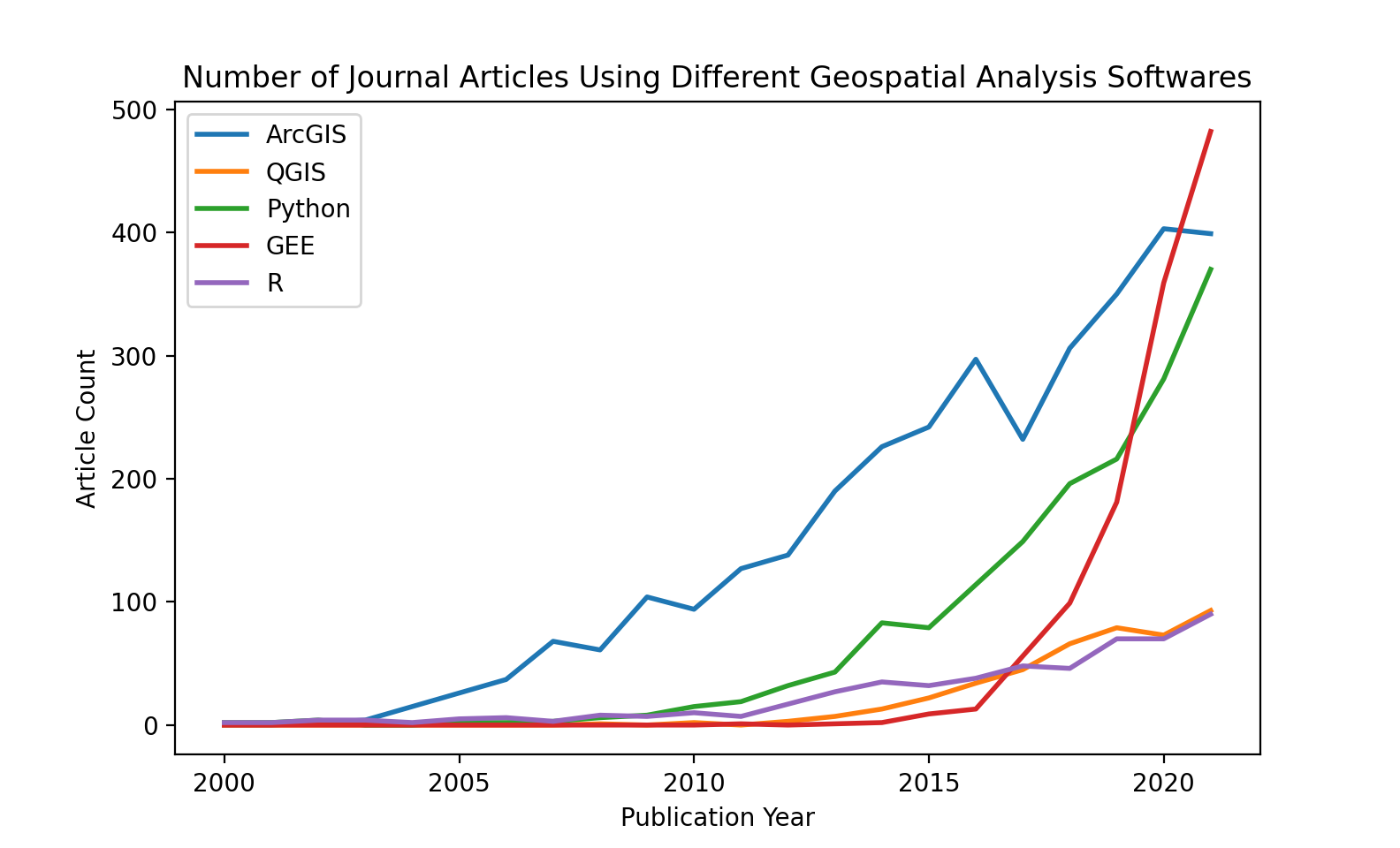
Despite only being released in 2015, the number of geospatial journal articles using Google Earth Engine (shown in red above) has outpaced every other major geospatial analysis software, including ArcGIS, Python, and R in just five years. GEE applications have been developed and used to present interactive geospatial data visualizations by NGOs, Universities, the United Nations, and the European Commission. By storing and running computations on Google servers, GEE is far more accessible to those who don’t have significant local computational resources; all you need is an internet connection.
Table of Contents
- Introduction
- Two introductory chapters that provide an overview of remote sensing the different types of satellite imagery available on Google Earth Engine.
- Google Earth Engine
- Recently, a team of over 100 scientists came together to write a book called “Cloud-Based Remote Sensing with Google Earth Engine: Fundamentals and Applications”. It’s a great resource for learning about remote sensing and Earth Engine. The material in this section is a subset of the book, edited to fit the scope of this guide. If you’re interested in learning more, check out the full book.
- Case Studies
- A series of case studies that demonstrate how to use Google Earth Engine for open source investigations. Each case study includes a brief introduction to the topic, a step-by-step guide to using Google Earth Engine to analyze satellite imagery, and a discussion of the results.